| |
 |
| |
In March 1861
British explorer Samuel White Baker (8 June 1821 – 30
December 1893) started upon his first tour of exploration
in central Africa. This, in his own words, was undertaken
"to discover the sources of the river Nile, with the
hope of meeting the East African expedition under Captains
Speke and Grant somewhere about the Lake Victoria." After
a year spent on the Sudan–Ethiopian frontier, during
which time he learned Arabic, explored the Atbara river and
other Nile tributaries, and proved that the Nile sediment
came from Ethiopia, he arrived at Khartoum, leaving that city
in December 1862 to follow up the course of the White Nile.
Two months later at Gondokoro he met fellow
British explorers Speke and Grant, who, after discovering
the source of the Nile, were following the river to Egypt.
Their success made him fear that there was nothing left
for his own expedition to accomplish; but the two explorers
gave him information which enabled him, after separating
from them, to achieve the discovery of Albert Nyanza (Lake
Albert), of whose existence credible assurance had already
been given to Speke and Grant. Baker first sighted the lake
on March 14, 1864. After some time spent in the exploration
of the neighbourhood, Baker demonstrated that the Nile flowed
through the Albert Nyanza. He formed an exaggerated idea
of the relative importance of the Albert and Victoria lake
sources in contributing to the Nile flow rate. Although
he believed them to be near equal, Albert Nyanza sources
add only ~15% to the Nile flow at this point, the remainder
provided primarily by outflow from Lake Victoria. He started
upon his return journey, and reached Khartoum, after many
checks, in May 1865.
In
the following October Baker returned to England with his
wife, who had accompanied him throughout the dangerous and
difficult journeys in Africa. In recognition of the achievements,
the Royal Geographical Society awarded him its gold medal,
and a similar distinction was bestowed on him by the Paris
Geographical Society.
|
| |
|
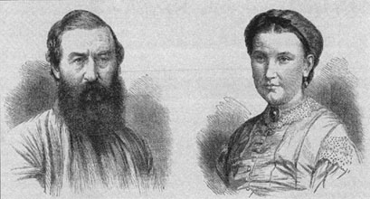 |
|
Sir
Samuel White Baker KCB, FRS, FRGS and his wife Florence
von Sass (Lady Baker) as illustrated in the London
News approx. 1873 |
|
In
August 1866 he was knighted. In the same year he published
The Albert N'yanza, Great Basin of the Nile, and Explorations
of the Nile Sources, and in 1867 The Nile Tributaries of Abyssinia,
both books quickly turned into several editions. In 1868 he
published a popular story called Cast up by the Sea. In 1869
he travelled with the future King Edward VII (who was the
Prince of Wales at that time) through Egypt.
Baker never received quite the same level of acclamation
granted to other contemporary British explorers of Africa.
Queen Victoria, in particular, avoided meeting Baker because
of the irregular way in which he acquired Florence, not
to mention the fact that during the years of their mutual
travels, the couple were not actually married.
|
| |
|
 |
|
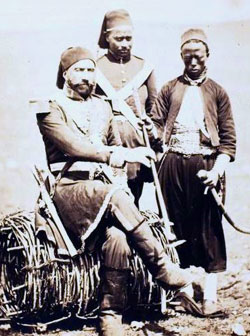
Isma'il
Pasha with attendants circa 1855 |
|
A court case involving his brother Valentine Baker (following
his indecent assault of a woman on a train) also harmed Baker's
chances of wider acceptance by the Victorian establishment.
Baker led a military expedition to the equatorial regions
of the Nile, with the object of suppressing the slave-trade
there and opening the way to commerce and civilization.
Before starting from Cairo with a force of 1700 Egyptian
troops - many of them discharged convicts - he was given
the rank of pasha and major-general in the Ottoman army.
Lady Baker, as before, accompanied him. The khedive appointed
him Governor-General of the new territory of Equatoria for
four years at a salary of £10,000 a year; and it was
not until the expiration of that time that Baker returned
to Cairo, leaving his work to be carried on by the new governor,
Colonel Charles George Gordon.
He had to contend with innumerable difficulties - the blocking
of the river in the Sudd, the hostility of officials interested
in the slave-trade, the armed opposition of the natives
- but he succeeded in planting in the new territory the
foundations upon which others could build up an administration.
|
|
| |
 |
| |
Nubia
The name Nubia is derived from that of the Noba people,
nomads who settled the area in the 4th century, with the
collapse of the kingdom of Meroë. The Noba spoke a
Nilo-Saharan language, ancestral to Old Nubian. Old Nubian
was used in mostly religious texts dating from the 8th and
15th centuries AD. Before the 4th century, and throughout
classical antiquity, Nubia was known as Kush, or, in Classical
Greek usage, included under the name Ethiopia (Aithiopia).
There were a number of small Nubian kingdoms throughout
the Middle Ages, the last of which collapsed in 1504, when
Nubia became divided between Egypt and the Sennar sultanate
resulting in the Arabization of much of the Nubian population.
Nubia was again united within Ottoman Egypt in the 19th
century, and within Anglo-Egyptian Sudan from 1899 to 1956.
Historically, the people of Nubia spoke at least two varieties
of the Nubian language group, a subfamily which includes
Nobiin (the descendant of Old Nubian), Kenuzi-Dongola, Midob
and several related varieties in the northern part of the
Nuba Mountains in South Kordofan. A variety (Birgid) was
spoken (at least until 1970) north of Nyala in Darfur but
is now extinct.
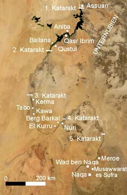
Throughout the world, Nubia is broken into three unique
regions: “Lower Nubia”, "Upper Nubia",
and "Southern Nubia." "Lower Nubia"
was in modern southern Egypt, which lies between the first
and second cataract. “Upper Nubia and Southern Nubia"
were in modern-day northern Sudan, between the second cataract
and sixth cataracts of the Nile river. Lower Nubia and Upper
Nubia are so called because the Nile flows north, so Upper
Nubia was further upstream and of higher elevation, even
though it lies geographically south of Lower Nubia.
|
|
Nubia and Ancient Egypt
Ancient Egypt conquered Nubian territory in various eras,
and incorporated parts of the area into its provinces. The
Nubians in turn were to conquer Egypt under its 25th Dynasty.
Relations between the two peoples however also show peaceful
cultural interchange and cooperation, including mixed marriages.
The Medjay –from mDA, represents the name Ancient
Egyptians gave to a region in northern Sudan–where
an ancient people of Nubia inhabited. They became part of
the Ancient Egyptian military as scouts and minor workers.
During the Middle Kingdom "Medjay" no longer
referred to the district of Medja, but to a tribe or clan
of people. It is not known what happened to the district,
but, after the First Intermediate Period, it and other districts
in Nubia were no longer mentioned in the written record.
Written accounts detail the Medjay as nomadic desert people.
Over time they were incorporated into the Egyptian army.
In the army, the Medjay served as garrison troops in Egyptian
fortifications in Nubia and patrolled the deserts as a kind
of gendarmerie. This was done in the hopes of preventing
their fellow Medjay tribespeople from further attacking
Egyptian assets in the region. They were even later used
during Kamose’s campaign against the Hyksos and became
instrumental in making the Egyptian state into a military
power. By the 18th Dynasty of the New Kingdom period the
Medjay were an elite paramilitary police force. No longer
did the term refer to an ethnic group and over time the
new meaning became synonymous with the policing occupation
in general. Being an elite police force, the Medjay were
often used to protect valuable areas, especially royal and
religious complexes. Though they are most notable for their
protection of the royal palaces and tombs in Thebes and
the surrounding areas, the Medjay were known to have been
used throughout Upper and Lower Egypt.
|
| |
|
Various pharaohs of Nubian origin are held
by some Egyptologists to have played an important part towards
the area in different eras of Egyptian history, particularly
the 12th Dynasty. These rulers handled matters in typical
Egyptian fashion, reflecting the close cultural influences
between the two regions.
...the XIIth Dynasty (1991–1786 B.C.E.) originated
from the Aswan region. As expected, strong Nubian features
and dark coloring are seen in their sculpture and relief
work. This dynasty ranks as among the greatest, whose fame
far outlived its actual tenure on the throne. Especially
interesting, it was a member of this dynasty that decreed
that no Nehsy (riverine Nubian of the principality of Kush),
except such as came for trade or diplomatic reasons, should
pass by the Egyptian fortress and cops at the southern end
of the Second Nile Cataract. Why would this royal family
of Nubian ancestry ban other Nubians from coming into Egyptian
territory? Because the Egyptian rulers of Nubian ancestry
had become Egyptians culturally; as pharaohs, they exhibited
typical Egyptian attitudes and adopted typical Egyptian
policies. (Yurco 1989)
In the New Kingdom, Nubians and Egyptians were often so
closely related that some scholars consider them virtually
indistinguishable, as the two cultures melded and mixed
together.
It is an extremely difficult task to attempt to describe
the Nubians during the course of Egypt's New Kingdom, because
their presence appears to have virtually evaporated from
the archaeological record. The result has been described
as a wholesale Nubian assimilation into Egyptian society.
This assimilation was so complete that it masked all Nubian
ethnic identities insofar as archaeological remains are
concerned beneath the impenetrable veneer of Egypt's material
culture. In the Kushite Period, when Nubians ruled as Pharaohs
in their own right, the material culture of Dynasty XXV
(about 750–655 B.C.E.) was decidedly Egyptian in character.
Nubia's entire landscape up to the region of the Third Cataract
was dotted with temples indistinguishable in style and decoration
from contemporary temples erected in Egypt. The same observation
obtains for the smaller number of typically Egyptian tombs
in which these elite Nubian princes were interred.
|
| |
|
 |
|
click
for larger view |
|
Kingdom of Kerma
The Turin Papyrus MapFrom the pre-Kerma culture, the first
kingdom to unify much of the region arose. The Kingdom of
Kerma, named for its presumed capital at Kerma, was one of
the earliest urban centers in the Nile region. By 1750 BC,
the kings of Kerma were powerful enough to organize the labor
for monumental walls and structures of mud brick. They also
had rich tombs with possessions for the afterlife and large
human sacrifices. George Reisner excavated sites at Kerma
and found large tombs and a palace-like structures. The structures,
named (Deffufa), alluded to the early stability in the region.
At one point, Kerma came very close to conquering Egypt. Egypt
suffered a serious defeat at the hands of the Kushites. According
to Davies, head of the joint British Museum and Egyptian archaeological
team, the attack was so devastating that if the Kerma forces
chose to stay and occupy Egypt, they might have eliminated
it for good and brought the great nation to extinction. When
Egyptian power revived under the New Kingdom (c. 1532–1070
BC) they began to expand further southwards. The Egyptians
destroyed Kerma's kingdom and capitol and expanded the Egyptian
empire to the Fourth Cataract. By the end of the reign of
Thutmose I (1520 BC), all of northern Nubia had been annexed.
The Egyptians built a new administrative center at Napata,
and used the area to produce gold. The Nubian gold production
made Egypt a prime source of the precious metal in the Middle
East. The primitive working conditions for the slaves are
recorded by Diodorus Siculus who saw some of the mines at
a later time. One of the oldest maps known is of a gold mine
in Nubia, the Turin Papyrus Map dating to about 1160 BC.
|
| |
|
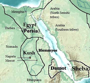 |
| |
The area
around 400 B.C. |
Kingdom
of Kush
Nubian PharaohsWhen the Egyptians pulled out of the
Napata region, they left a lasting legacy that was merged
with indigenous customs forming the kingdom of Kush.
Archaeologists have found several burials in the area
which seem to belong to local leaders. The Kushites
were buried there soon after the Egyptians decolonized
the Nubian frontier. Kush adopted many Egyptian practices,
such as their religion. The Kingdom of Kush survived
longer than that of Egypt, invaded Egypt (under the
leadership of king Piye), and controlled Egypt during
the 8th century, Kushite dynasty. The Kushites held
sway over their northern neighbors for nearly 100 years,
until they were eventually repelled by the invading
Assyrians. The Assyrians forced them to move farther
south, where they eventually established their capital
at Meroë. Of the Nubian kings of this era, Taharqa
is perhaps the best known. Taharqa, a son and the third
successor of King Piye, was crowned king in Memphis
in c.690. Taharqa ruled over both Nubia and Egypt, restored
Egyptian temples at Karnak, built new temples and pyramids
in Nubia, and repelled some Assyrian attacks. |
|
|
| |
 |
|
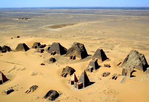
The
pyramids at Meroë |
|
| |
|
Meroë
Meroë (800 BC – c. AD 350) in southern Nubia lay
on the east bank of the Nile about 6 km north-east of the
Kabushiya station near Shendi, Sudan, ca. 200 km north-east
of Khartoum. The people there preserved many ancient Egyptian
customs but were unique in many respects. They developed their
own form of writing, first utilizing Egyptian hieroglyphs,
and later using an alphabetic script with 23 signs. Many pyramids
were built in Meroë during this period and the kingdom
consisted of an impressive standing military force. Strabo
also describes a clash with the Romans in which the Romans
were defeated by Nubian archers under the leadership of a
"one-eyed" (blind in one eye) queen. During this
time, the different parts of the region divided into smaller
groups with individual leaders, or generals, each commanding
small armies of mercenaries. They fought for control of what
is now Nubia and its surrounding territories, leaving the
entire region weak and vulnerable to attack. Meroë would
eventually meet defeat by a new rising kingdom to their south,
Aksum, under King Ezana.
The classification of the Meroitic language is uncertain,
it was long assumed to have been of the Afro-Asiatic group,
but is now considered to have likely been an Eastern Sudanic
language. At some point during the 4th century, the region
was conquered by the Noba people, from which the name Nubia
may derive (another possibility is that it comes from Nub,
the Egyptian word for gold). From then on, the Romans referred
to the area as the Nobatae.
Christian Nubia: Makuria, Nobadia,
and Alodia
Around AD 350 the area was invaded by the Ethiopian kingdom
of Aksum and the kingdom collapsed. Eventually three smaller
kingdoms replaced it: northernmost was Nobatia between the
first and second cataract of the Nile River, with its capital
at Pachoras (modern day Faras); in the middle was Makuria,
with its capital at Old Dongola; and southernmost was Alodia,
with its capital at Soba (near Khartoum). King Silky of
Nobatia crushed the Blemmyes, and recorded his victory in
a Greek inscription carved in the wall of the temple of
Talmis (modern Kalabsha) around AD 500.
While bishop Athanasius of Alexandria consecrated one Marcus
as bishop of Philae before his death in 373, showing that
Christianity had penetrated the region by the 4th century,
John of Ephesus records that a Monophysite priest named
Julian converted the king and his nobles of Nobatia around
545. John of Ephesus also writes that the kingdom of Alodia
was converted around 569. However, John of Biclarum records
that the kingdom of Makuria was converted to Catholicism
the same year, suggesting that John of Ephesus might be
mistaken. Further doubt is cast on John's testimony by an
entry in the chronicle of the Greek Orthodox Patriarch of
Alexandria Eutychius, which states that in 719 the church
of Nubia transferred its allegiance from the Greek to the
Coptic Church.
|
| |
|
By the 7th century Makuria expanded becoming the dominant
power in the region. It was strong enough to halt the southern
expansion of Islam after the Arabs had taken Egypt. After
several failed invasions the new rulers agreed to a treaty
with Dongola allowing for peaceful coexistence and trade.
This treaty held for six hundred years. Over time the influx
of Arab traders introduced Islam to Nubia and it gradually
supplanted Christianity. While there are records of a bishop
at Qasr Ibrim in 1372, his see had come to include that located
at Faras. It is also clear that the cathedral of Dongola had
been converted to a mosque in 1317.
The influx of Arabs and Nubians to Egypt and Sudan had
contributed to the suppression of the Nubian identity following
the collapse of the last Nubian kingdom around 1504. A major
part of the modern Nubian population became totally Arabized
and some claimed to be Arabs (Jaa'leen – the majority
of Northern Sudanese – and some Donglawes in Sudan).
A vast majority of the Nubian population is currently Muslim,
and the Arabic language is their main medium of communication
in addition to their indigenous old Nubian language. The
unique characteristic of Nubian is shown in their culture
(dress, dances, traditions, and music).
Islamic Nubia
In the 14th century the Dongolan government collapsed and
the region became divided and dominated by Arabs. The next
centuries would see several Arab invasions of the region,
as well as the establishment of a number of smaller kingdoms.
Northern Nubia was brought under Egyptian control while
the south came under the control of the Kingdom of Sennar
in the 16th century. The entire region would come under
Egyptian control during the rule of Mehemet Ali in the early
19th century, and later became a joint Anglo-Egyptian condominium.
|
| |
|
| |
| |
|


